INTRODUCTION
The Cinque Terre — Monterosso al Mare, Vernazza, Corniglia, Manarola and Riomaggiore — are among the most photographed symbols of the Ligurian coast. Colorful houses clinging to cliffs, terraced vineyards and turquoise coves draw hundreds of thousands of visitors each year. Yet beyond the famous trails like the Sentiero Azzurro and the well-known Via dell’Amore, there are quieter, lesser-known hikes that let you rediscover these villages away from the crowds, breathing in rosemary-scented air and soaking up sea vistas that make you feel like you have the place to yourself.
This guide will lead you step by step to those tucked-away paths: walks that start on the edge of town, cut through olive groves, terraced vines and umbrella pines, and end on headlands with breathtaking panoramic views. Each route below includes a precise starting point, useful addresses (usually a square or train station that’s easy to find), practical tips (recommended times, costs when applicable, difficulty level) and local advice so you can make the most of the experience without getting stuck on overcrowded trails.
Why seek out these secret routes? Because they offer a different kind of experience: soft morning light on facades, a silence broken only by cicadas and waves, and the chance to stop for a picnic on a natural lookout without a constant stream of tourists. These routes are great for hikers who want to combine exercise, photography and tasting local specialties (Ligurian pesto, focaccia di Recco, Cinque Terre DOC wines) in less commercial settings. They suit both experienced walkers and families willing to walk a little further to reap the rewards.
Before we dive into the routes, a few essential practical notes: download the official Parco Nazionale delle Cinque Terre map and check trail conditions on the park’s website (or at the park office in Monterosso); wear comfortable closed hiking shoes; bring enough water (public fountains are not guaranteed on every stretch); respect vegetation and private property; and, finally, start early to catch the most photogenic light and pleasant temperatures, especially in summer. The sections below present five “secret” hikes — each with descriptions, exact addresses, suggested times, possible fees and local tips — so you can pick the one that best matches your curiosity and fitness level.
Punta Mesco and the Hermitage of San Cristoforo (Monterosso)
Route: Start at Piazza Garibaldi, Monterosso al Mare — address: Piazza Garibaldi, 19016 Monterosso al Mare SP, Italy. This hike leaves from Monterosso’s old town on the Levante side and climbs up toward Punta Mesco, the headland that separates Monterosso from Levanto. The trail isn’t one of the most famous stretches of the Sentiero Azzurro and, especially off-season, remains relatively quiet. Plan on 2 to 3 hours round-trip depending on your breaks and pace.
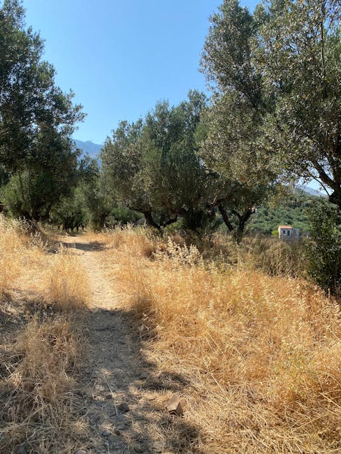
Immersive description: You leave Fegina beach and climb through terraced vineyards and Mediterranean scrub. The scents of thyme and wild fennel accompany the ascent. At Punta Mesco the view fans out: to the east lies Levanto bay, to the west the orange roofs of Monterosso, and on clear days you can make out distant islands and the headland of Portofino. On the promontory you’ll see remnants of military works and small natural platforms perfect for watching the sunset.
Practical info: access is free. The Parco Nazionale delle Cinque Terre recommends starting early (ideally between 7:00 and 9:00). There are no public toilets on the headland; bring water and snacks. Trail surface: dirt and rock — a good pair of shoes is required. Difficulty: easy to moderate (average elevation gain).
Local tip: do this hike at sunrise in summer to avoid the heat and capture golden light on the sea. Check with the “Punto Informazioni Parco” located on Lungomare Cristoforo Colombo (address: Lungomare Cristoforo Colombo, 19016 Monterosso al Mare SP) — opening hours are often 9:00–17:00 depending on the season — to learn about current trail conditions.
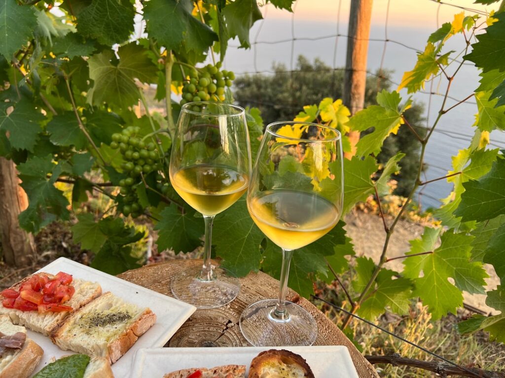
Volastra Vineyard Trail from Corniglia (an alternative panoramic route)
Route: Recommended start: Piazza San Pietro, Corniglia — address: Piazza San Pietro, 19016 Corniglia SP, Italy. This hike climbs from Corniglia up to the vineyard-dotted hamlet of Volastra, then follows paths through terraced vineyards that offer unique perspectives on the five villages. Less traveled than the direct coastal stretch, this circuit is a concentrated dose of rural life and historic agricultural landscapes.
Immersive description: From the first slopes you’ll notice dry-stone walls and hand-cut steps — evidence of centuries of labor. These vineyards produce the famous Sciacchetrà (a local sweet wine) and the trail passes small family wineries and rural chapels. In summer, ripe grape clusters and fermented scents add another sensory layer to the walk. Views from Volastra and the intermediate ridges allow you to take in the sea, bands of colorful villages and the geometric lines of the terraces.
Practical info: access is free. The Corniglia–Volastra stretch is mainly uphill on steps and rocky paths; difficulty: moderate. Allow 3 to 4 hours if you plan to return via a different route and explore less-trodden park sections. Drinking fountains are available in Corniglia (near the station: Via Fieschi, 19016 Corniglia) but not always along the trail.
Local tip: bring a paper map or an offline GPS file (signage can be missing in places). Stop by the Chiesa di San Pietro (address: Piazza San Pietro, 19016 Corniglia) — often open 9:30–18:30 in high season — for its understated interior and commanding position. After the hike, reward yourself with a glass of Sciacchetrà at Azienda Agricola Ca’ de Frà (check opening hours and availability locally).
The « Via del Mare » from Manarola to the Punta Bonfiglio Viewpoint
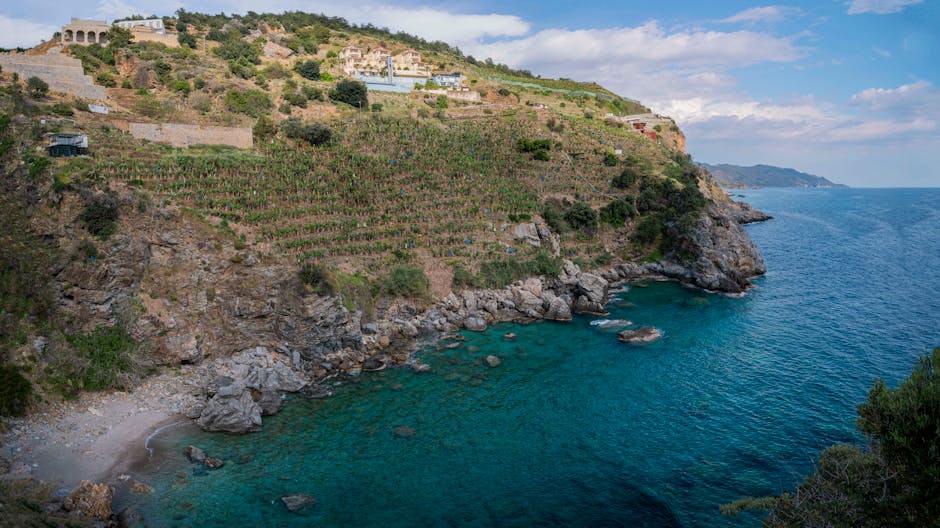
Route: Start: Manarola, Piazza G. Matteotti — address: Piazza Giacomo Matteotti, 19017 Manarola SP, Italy. Unlike the main coastal trail, this variant follows old mule tracks and descends to rocky coves that are hard to reach from the sea. It continues to the Punta Bonfiglio viewpoint, offering incredible photo angles of Manarola and Riomaggiore.
Immersive description: The descent takes you into wild vegetation dotted with wind-sculpted olive trees and ancient stone markers. Midway you’ll find a small natural terrace with an intimate view of an offshore rock arch and the cliffs. Continuing toward Punta Bonfiglio, you cross scree slopes and salty rock pools where you can often spot fish from the limestone outcrops. Evening light makes Manarola’s facades glow, and the viewpoint is perfect for golden hour photography.
Practical info: the route includes narrow sections and a technical descent: sturdy shoes are mandatory and hiking poles are recommended. Expect about 2 to 3 hours round-trip. There is no access fee. The trail can be closed in bad weather; updates are typically posted at Manarola Station reception (address: Piazza G. Matteotti, 19017 Manarola) and at the park office.
Local tip: head out late afternoon to catch the blue hour behind Manarola, but be back up before full darkness if you don’t have lighting. Local fishermen sometimes use the small coves; respect their areas and avoid blocking private access. For a food stop, Trattoria Dal Billy (Via Renato Birolli, 1R, 19017 Manarola) offers local dishes — book ahead if you want to dine there (typical hours: 12:00–15:00 and 19:00–22:00; prices roughly €12–25 per dish).
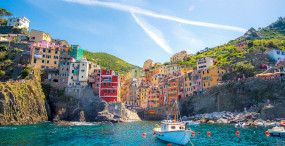
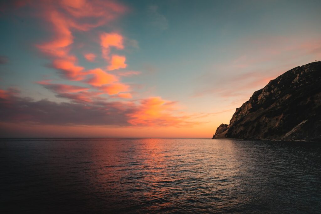
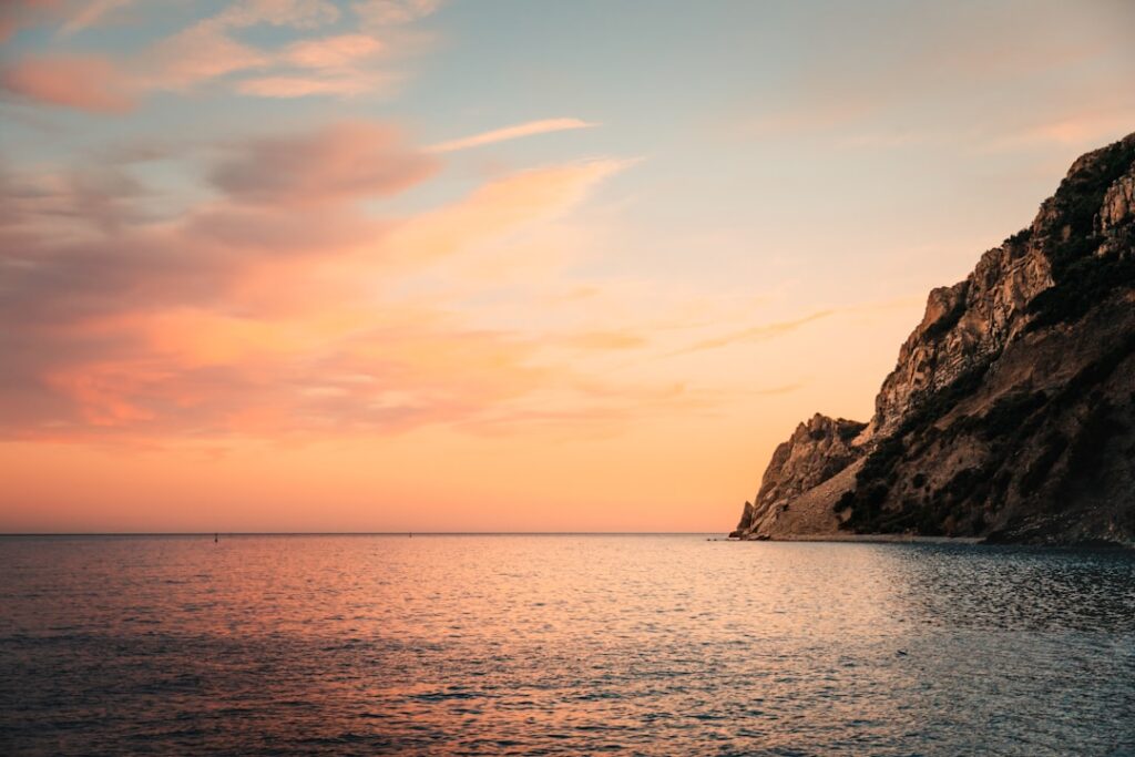
The Secret Ridge between Riomaggiore and Portovenere via Campiglia
Route: Recommended start: Stazione di Riomaggiore — address: Piazza Cappellini, 19017 Riomaggiore SP, Italy. This lesser-known hike isn’t strictly within the classic Cinque Terre boundaries but links Riomaggiore to the inland route toward Portovenere, passing the hamlet of Campiglia and often-empty panoramic ridges. It’s a longer outing (half-day to full day) that offers total immersion in Ligurian nature and rural history.
Immersive description: After leaving Riomaggiore the path climbs toward Campiglia, a cluster of stone houses and isolated small terraces. Coastal panoramas alternate with forest paths, lookout points where you might spot cormorants, and small rocky outcrops perfect for a break. This route reveals a different face of Liguria: a human-shaped landscape that’s remote but rich in biodiversity and dotted with tiny chapels like the Chiesa di San Giovanni Battista in Campiglia (check opening times).
Practical info: bring water, food for the day and a detailed map or GPS. Difficulty: moderate to hard depending on the chosen route (some sections demand strong legs). No tolls; if you plan to end in Portovenere and take a ferry back to La Spezia, check ferry schedules: Porto Venere Ferry Terminal — address: Molo dei Marmi, 19025 Porto Venere SP, Italy. Ferry fares vary (approx. €4–10 depending on distance and season).
Local tip: start before 8:00 in summer to avoid the heat and increase your chances of wildlife sightings. Pack a swimsuit — the coves around Portovenere are perfect for a cleansing dip to finish the day. Check local bus times if you prefer a shorter return: regional buses and Trenitalia connections serve Porto Venere to La Spezia (schedules vary; verify online the day before).
Unexplored Coastal Circuits around Rio Soviore and the Punta Corone Battery
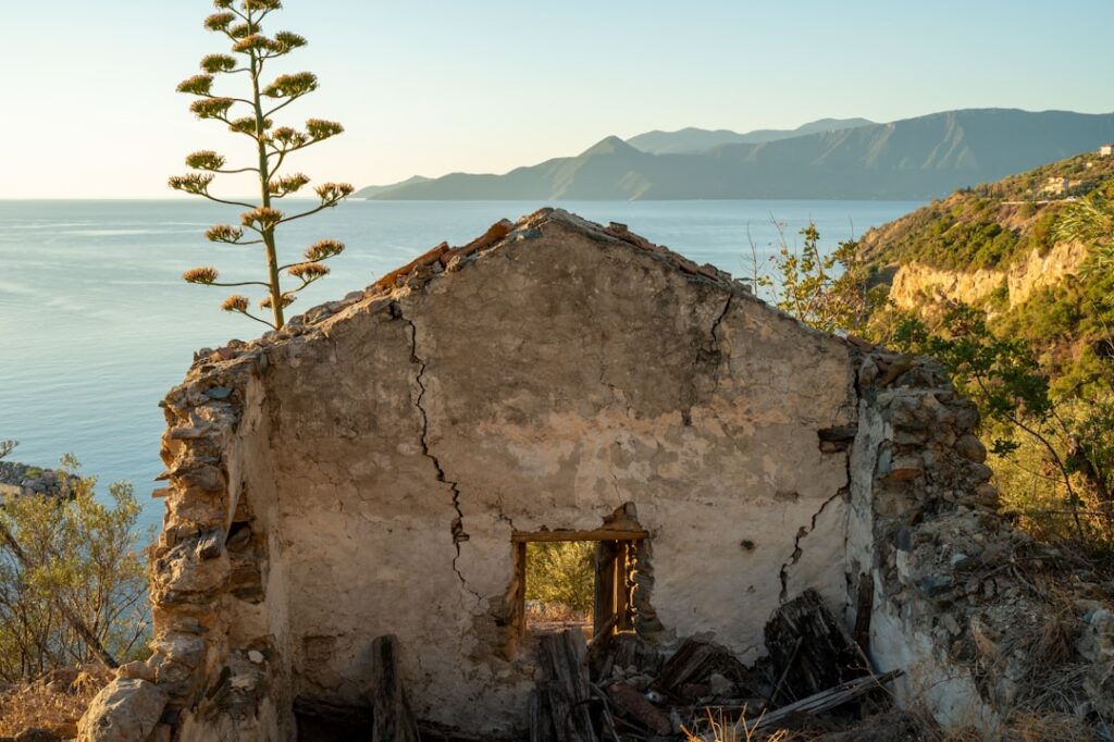
Route: Start: Monterosso al Mare, extending toward the Soviore valley — landmark: Parco Soviore trailhead, often accessible from Via XX Settembre and the hamlet of Soviore (reference address: Via Soviore, 19016 Monterosso al Mare SP). This hike combines forest trails, forgotten military ruins (coastal batteries) and discreet coves. The Punta Corone Battery (military remains) is a fascinating spot for those interested in history and dramatic sea views.
Immersive description: The descent into Soviore crosses cork oak and pine forest, with zones where the smell of resin is strong. Remnants of coastal batteries — rusted guns and stone shelters — tell a strategic history of the coast. After the battery, the trail leads to rocky outcrops that overlook small pebble beaches rarely shared with many other visitors. Morning light accentuates rock textures and the clarity of the water, ideal for underwater photography enthusiasts.
Practical info: access is free. Some sections are technical (slippery rocks after rain). This route is recommended for experienced hikers or those accompanied by a local guide. There are no services at the battery; bring water and a basic first-aid kit. If you plan to explore the ruins, be careful around unstable areas and respect park regulations that prohibit crossing certain barriers.
Local tip: ask at the Centro Visite “Museo del Parco” (address: Via Roma, 19016 Monterosso al Mare SP — indicative hours 9:00–17:00 outside high season) about authorized access to military sites. The best times are spring and late summer, when vegetation is lush and visitor numbers are lower. Bring a mask and snorkel: the water near the batteries is often crystal clear and excellent for snorkeling.
CONCLUSION
The Cinque Terre are more than a string of postcards: they are a living landscape shaped by centuries of agricultural labor, rocky islets and maritime traditions. Exploring the secret hikes described here — Punta Mesco, Volastra’s vineyards, the Manarola paths to Punta Bonfiglio, the ridge via Campiglia and the ruins around Soviore — lets you soak up an atmosphere that a quick visit to the main tourist spots can’t provide. These routes blend physical effort, natural beauty and quiet encounters with local producers, fishermen and villagers who keep these places alive.
Practically speaking, a few reminders: always check current trail conditions with the Parco Nazionale delle Cinque Terre (information points in Monterosso and La Spezia), carry plenty of water (public fountains are not everywhere), wear appropriate shoes and pack sun protection. The Cinque Terre Card can be useful: the Cinque Terre Card — Trekking is generally around €7.50 per day for trail access and signage; the Cinque Terre Card — Train + Trekking allows unlimited travel on the local train line and often costs around €16 per day (prices change — check the official site before you leave). These cards are sold at stations (Monterosso Galleria ticket office) and park information points.
Opening hours vary: cultural sites and some restaurants follow seasonal schedules — for example, the Chiesa di San Giovanni Battista in Monterosso (Piazza San Giovanni, 19016 Monterosso al Mare) is typically open 9:00–19:00 in high season; most trattorie open at midday and in the evening (common hours: 12:00–15:00 and 19:00–22:00). Ferries between the villages and Porto Venere operate mainly from April to October with varying timetables (fares approx. €4–10 depending on distance). Always confirm on official sites or at local info desks to avoid surprises.
Above all, the spirit of these secret hikes is respect: leave no trace, don’t pick plants or damage dry-stone walls, respect private access and local fishermen. By following these principles you’ll help preserve the magic of the Cinque Terre for future generations. Start early, take your time, and let yourself be surprised by panoramas few visitors get to enjoy — you’ll leave with strong images in your head, local flavors on your palate and the feeling of having discovered a slice of Italy almost all to yourself.

[[IMAGE:Riomaggiore coastal cliff trail morning]]
[[IMAGE:Old stone terrace vineyard pathway]]
[[IMAGE:Local fisherman docked boat morning]]